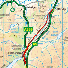
Dalwhinnie
7 miles
After
traveling through the Pass of Drumochter we turn left into the sleepy
village of Dalwhinnie situated on the River Truim and home to the
attractive buildings of the Dalwhinnie distillery and weather station.
Westwards on the fringe of Badenoch (from the Gaelic, meaning ‘Drowned
Land’), stretches the lonely Loch Ericht, 15 miles in length
and at the far western extremity rises the remote peak of Ben Alder
(3757ft).
Past the distillery we turn right on the road to Crubenmore. It was
in this vicinity that Sir John Cope failed to intercept Prince Charles
Edward Stuart in 1745. A year later the Prince was a fugitive in the
same district, one of his hiding places being the so-called “Cluny’s
Cage”, below the southern slopes of Ben Alder, and described
by Robert Louis Stevenson in his story “Kidnapped”.
Our road now descends gradually through Glen Truim with the railway
to our right and the traffic on the new road beyond. We eventually
come to Crubenmore bridge over the River Truim which is a concrete
structure built in 1925-26 designed by Sir Owen Williams who also
designed a number of other bridges along the Old A9 and was the Head
Engineer for the original Wembley stadium. The bridge is listed. Over
to the right is the Old Crubenmore Bridge built around 1800-1810.
Further on and before the road crosses the railway is a parking area
to the right with information boards about the local area.
On the opposite side of the road is a short walk down to the Falls
of Truim and Crubenbeg bridge built around 1730 on Wade’s military
road.
We now cross the railway and rejoin the new road.